Whether you're using Apple Maps or Google Maps, maps have been an integral part of our daily lives. However, have you ever had a map give you the wrong information? I have. At that point, I was traveling abroad and navigated to a restaurant, but when I arrived only to found that it had closed down.
Undoubtedly, the outdated information always causes great inconvenience. So, understanding how frequently maps update can be important. This time, we will explore how often Google Maps updates and what contributes to these updates.
Here's a quick breakdown of how often Google Maps updates:
Data Type
Update Frequency
Satellite Image
Every 1 to 3 years (urban areas) / 3 to 5 years (rural areas)
Street View
Every 2 years (urban areas) / 3+ years (rural areas)
Traffic Data
Every 5 to 10 minutes (high-traffic areas) / 30 to 60 minutes (low-traffic areas)
Shared Location
Real-time updates
Points of Interest
Updated daily to monthly
*Note: Google Maps does not have an official update schedule, so this table is for reference only. What's more, the frequency of updates may vary depending on different situations.
For Satellite Images
Satellite images look like photographs of the Earth's surface, offering the most realistic view of geographical areas. Google Maps relies on satellite imagery captured by commercial satellites and aerial photos to offer a high-quality satellite view.
The update cycle is:
Urban Areas: Satellite images are updated every 1 to 3 years. This lets users look at the most recent infrastructure, new buildings, and road construction.
Rural Areas: Upgrades in rural areas with small populations are not as frequent and are typically only every 3 to 5 years.
Natural Disasters & Regions: In regions that have been hit by natural disasters, images may be updated more frequently so relief services and navigation can access the latest information.
For Street View Panorama
Street View provides 360-degree imagery of roads, allowing you to explore locations virtually. Like satellite images, Street View updates depend on regions.
Urban Areas: In urban and busy areas such as tourist attractions, Street View is updated approximately every 2 years.
Rural Areas: Rural roads, suburban areas, and less-frequent streets may take 3 years or more to receive updated imagery.
For Traffic Data
Google Maps provides real-time traffic information derived from GPS signals, road sensors, and user feedback. The frequency of updates depends on road conditions.
High-Traffic Areas: Traffic is updated every 5 to 10 minutes in major cities and highways to offer accurate congestion information, estimated travel times, and alternate routes.
Low-Traffic Regions: On rural and low-volume roads, there are refresh rates every 30 to 60 minutes based on fewer data sources.
For Shared Location
Google Maps' location-sharing feature is updated in real time. With a good GPS signal and an ongoing internet connection, location tracking is very accurate. However, there are times when Google Maps cannot update shared location. At this time, we suggest using an alternative way to fetch live location.
For Points of Interest (POI)
Points of Interest (POIs) are business establishments, landmarks, and public transportation stops. Google Maps periodically refreshes them based on submissions from business owners, user contributions, and artificial intelligence detection.
Popular places like shopping centers and eateries are refreshed daily or weekly, whereas small businesses and rural landmarks may take months or years to update.
Factors That Affect Google Maps Update Frequency
Several factors influence Google Maps' update frequency. Understanding this provides insight into how Google Maps update its data.
Data Source and Availability
To collect map data, Google Maps uses satellites, aerial photography, vehicles equipped with 360° cameras, public data, business listings, etc. However, the data collection may be suspended or delayed due to development, weather, costs, or emergencies.
For example, adverse weather conditions such as snow or poor visibility not only make satellites challenging to capture images but also affect the quality of images captured by Street View vehicles.
Regions
Cities that are in a state of constant rapid development and infrastructure changes are updated more regularly. Their satellite imagery, Street View, and Points of Interest are periodically updated because their technological infrastructure facilitates more comprehensive and timely data collection.
Rural and low-population areas take years to update since demand is minimal and there are few data points. Moreover, due to poor signals and infrastructures, even if the data is obtained, it will take a long time to be uploaded to the Google Maps database.
Users' Feedback
Google Maps also encourages users to submit reports to update map information. Users can suggest edits to business details, report incorrect addresses, or highlight missing roads. These reports, especially for POI and navigation routes are reviewed and, if verified, incorporated and updated into the map.
Significant Events
Natural disasters, major construction projects, and large-scale events can prompt faster updates. Natural disasters such as earthquakes, hurricanes, or floods can trigger quicker updates by Google to facilitate proper navigation and road conditions. In a similar vein, the construction of new highways, bridges, and city developments may trigger quicker updates in specific areas.
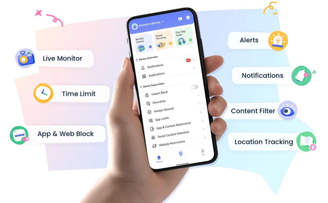
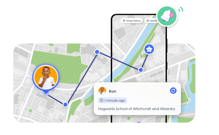
Bonus: Get Real-Time Location of Your Family Members
If you're using Google Maps to share location with your family members, you may need to pay extra attention because it may happen that the location does not update or they stop sharing the location with your knowledge.
This time, we suggest you using specific apps like AirDroid Parental Control to avoid the above issues.
This app has features purposefully designed to monitor the surroundings and well-being of your loved ones. You can know the live location of family members and review the route history to ensure their safety. Moreover, it lets you observe their surroundings if your child is using an Android.
FAQs about Google Maps View
Google Maps satellite imagery is outdated, so how do you request updates?
If you notice that the satellite imagery on Google Maps is outdated, you can request an update by following:
Step 2.Then, enter the basic info of the landmark and report the outdated or incorrect info.
Step 3.Click Send to submit your feedback to Google.
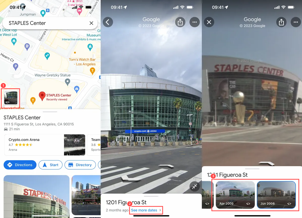
How do you see older Google Maps Street views?
Google Maps has a feature that allows you to view historical Street View photos and have virtual "time travel." Here is how you can do it:
Step 1.Enter the address in the search field of Google Maps.
Step 2.Tap on the "Street View" icon in the bottom left to access the panoramic view.
Step 3.Tap on "See more dates" and you can view available historical imagery.
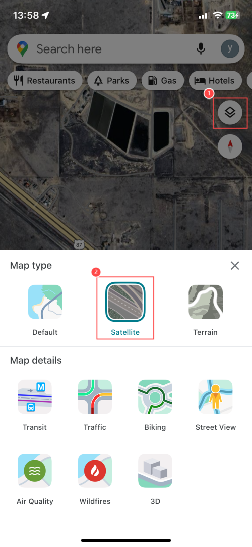
How do you change Google Maps to satellite view?
To switch to satellite view in Google Maps, just tap the layers icon (two stacked squares) in the top-right corner. Then, you can choose the "Satellite" option to switch to the map view.
Elsa has worked on a number of iOS & Android solutions, she can always find her way around almost any application. She is an accomplished, skilled and versatile writer with more than 7 years of technical article writing experience.


Leave a Reply.